


Jim Moore / October 25, 2026
BLUFF POINT – Take a drive along the Skyline Drive on a sunny afternoon in fall, and everything seems to have already found its rightful owner. In between the two branches of Keuka Lake, the land is filled with geometric vineyards, old barns and lakeside cabins where Yates County’s residents lived for many generations.
But just below the grass and roots covering this windswept ridge is the specter of one of the area’s oldest riddles – which, unfortunately, settlers uprooted before science got a chance to solve it.
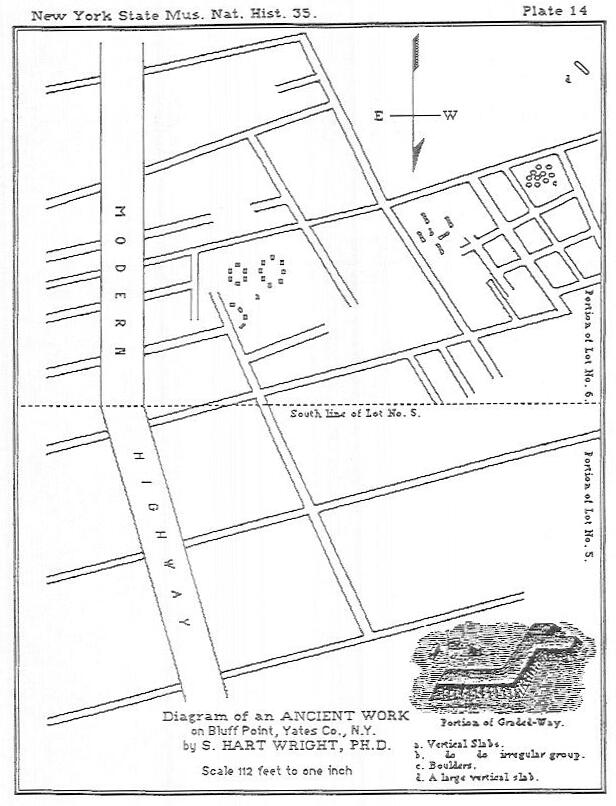
Well before summertime visitors made their way to the Bluff, the top of the ridge was the home to the Bluff Point Stoneworks – a unique archaeological site covering nearly eight acres. What made this site distinct from other sites in upstate New York were its earthen banks covered with stone slabs, geometric enclosures and avenues built straight towards the top of the hill.
The earliest systematic effort to document the remains came during the last decades of the 19th century, when Penn Yan botanist and surveyor Dr. Samuel Hart Wright, produced an extensive map of the site.
Wright was awestruck. He commented in his report for the New York State Museum of Natural History in 1884 that the site seemed to have no counterpart in contemporary northeast American archaeology. It was devoid of the defensive earth and timber stockade common to known Iroquoian hilltop fortifications, and it also possessed no means of access to fresh water due to its vulnerable location. Rather, it appeared that there was some intentionality to its design, something ceremonial or astronomical-looking over the water.
When the early pioneers asked local Seneca tribal elders about the origin of the stone remains, the response always remained consistent – the stones had always been there, erected by people ancient to their grandfathers’ memory.
Because the stone of the site was a valuable construction material, in the 1880s farmers hauled wagon after wagon of the smooth flagstones off to form the foundation of their homes, the linings of their root cellars, and the walls of their property boundaries. When test trenches were dug by amateur archaeologists in the late 1930s, many years of farming and orchards had already destroyed the surface formations, and what little survived went to private collections.
From 1938 to 1939, an amateur archaeology dig was organized and conducted under the guidance of Gilbert T. Brewer, a renowned writer for newspapers and a history buff, who hailed from Canandaigua.
The team commenced the excavation process by digging several test trenches, pits, and large shafts on the thick, bushy landscape of the ridge.
In the course of their fieldwork, they claimed to have found considerable amounts of charcoal layers, primitive stone implements, and purported iron/ metal objects.
Unfortunately, due to Brewer having no formal background in professional archaeology, the entire project was devoid of any scientific methodology, documentation, and stratigraphy. As a result, the majority of the recovered artifacts, known collectively as the “Brewer Collection,” got lost over the decades, making it practically impossible for any future lab testing and dating.
As late as 1991 Wright’s 1879-80 work was reviewed and summarized by David B. Kelley and Virginia Gibbs in their work “Ancient Earth & Stone Ruins in Yates County, New York”.
Today there is nothing left above ground. The site rests peacefully in private ownership, covered with brush and trees.
Nevertheless, the local historians still haven’t completely abandoned their efforts to unlock the ridge’s secrets. In the times when aerial LiDAR and ground penetrating radar allow to see what’s under many feet of topsoil, tracing all ditch lines and stone footings without any excavations, there might be another secret left to discover.
Until then, however, the Bluff will still keep its secrets as a reminder that before the hills were transformed into fields and vineyards, an earlier civilization was looking at the same blue waters, for reasons currently unknown to us.
For more about the Bluff Point Stoneworks see
- David D. Robinson: “Mysterious Ruin at Bluff Point,” published in The Crooked Lake Review (Issue #68, November 1993)
- David B. Kelley and Virginia Gibbs (Yates County Historian): “Pre-Colonial Earthen & Stone Ruins in Yates County, New York” (1981, rev. 1988/1991
- Christopher A. Wright: “The Bluff Point Stoneworks” (Yates County Historical Society, April 1980).
image: S. Hart Wright‘s drawing of the Stoneworks Wikipedia